




When Jhed Tamano, a 22-year-old Filipino environmental activist, organized fishing communities to protest against a USD 15-billion “green airport” project, her life changed forever. Tamano and her colleague, Jonila Castro, were abducted by soldiers in September 2023 and held for 17 days.
In a revealing twist, when the military attempted to present them at a press conference as communist rebels who had voluntarily surrendered, the activists turned the stage on their captors; they revealed how they had been kidnapped and forced to sign false statements under death threats for opposing the airport project just north of Manila in Bulacan province. This defiant act was amplified by rights groups, which forced their immediate release later that day into the custody of the Commission on Human Rights, an independent constitutional body mandated to protect victims of state abuse in the Philippines.
Despite a Supreme Court order granting them temporary protection, legal persecution continued. In August 2024, the Court of Appeals denied their petition for permanent protective writs, claiming a “lack of evidence” of imminent threats. The activists also face a criminal charge of “grave oral defamation” filed by the military.
Tamano and Castro now live in fear, forced to watch over their shoulders at all times, in a coastal community whose shoreline is being reshaped by the airport project they risked everything to oppose.
“Before, we were just activists. Now, for opposing a ‘development’ project, we are called terrorists. The state uses the green agenda to justify surveillance, red-tagging [the practice of labeling entities as communists or enemies of the state], and violence. They are not protecting the environment; they are protecting the project,” Tamano said.
Tamano’s story reveals a familiar logic of extraction under the name of green and sustainable development in Southeast Asia. Land is seized, dissent is criminalized, and technology is weaponized to protect what is, at its core, a nexus of state and corporate interests.
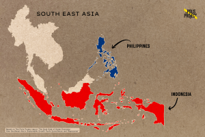
The same pattern can be traced to the island of East Kalimantan in Indonesia, where the new capital Nusantara is being built. The government claims they are trying to build one of the most sustainable cities in the world. But at what cost? This project requires more than 256,000 hectares of land, an area larger than the present capital, Jakarta. Much of this land is customary territory of the Indigenous Dayak and Balik communities who have cultivated it for generations, and is also a key biodiverse space for various plant and animal species.
They are not protecting the environment; they are protecting the project.
The government insists that land acquisition for Nusantara has followed legal procedures and that adequate compensation is being provided. The reality is quite different. Atim, a 58-year-old Balik farmer, was tending sago palms his grandfather had planted when survey teams arrived without warning, drove wooden stakes into his land, and left. It was just a few months after construction of Nusantara began in 2022.
The stakes were part of surveying for the Sepaku River intake and flood management project, a core piece of Nusantara’s infrastructure. That project has since overridden customary land claims while razing farms and even relocating centuries-old Balik community graves.
Atim’s community’s bond with the land long predates any state claim. Atim keeps a rusted machete, not for defense, but to clear vines from ancestral graves, he says. One day while weeding at the grave site, Atim found the survey markers and realized that his ancestral land had been claimed.
“They act like we don’t exist,” he said. “There is no communication.”
Across the Nusantara site, communities have reported similar experiences: survey teams arrived unannounced, marked land for clearance, and people received offers of compensation only after construction had already begun. The government’s promise of dialogue, repeated in press releases and international investor briefings, seldom took place in the villages. For those who remain, extensive mangrove destruction has polluted water sources and worsened flooding, destroying the harvests families like Atim’s depend on.
What connects Bulacan and East Kalimantan is not just the displacement, but the logic that justifies it. Both projects are framed as green, sustainable, and essential for the nation’s future. In the Philippines, the airport is “climate-resilient infrastructure”. In Indonesia, Nusantara is a “smart forest city”. Under this banner of green development, communities are forced to surrender their land to the state and its corporate partners, and any resistance is held as a threat to national development rather than a legitimate grievance.
‘Greenwashed’ Projects Mask Displacement
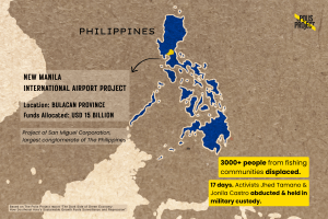
With its long coastlines, densely populated low-lying cities, and growing exposure to floods, typhoons and heatwaves, Southeast Asia sits on the front line of the climate crisis, intensifying pressure on governments to shift toward a greener, more resilient economy. In this backdrop, the USD 15 billion New Manila International Airport (NMIA), a project of the Philippines’s largest conglomerate San Miguel Corporation, and supported by Dutch engineering firms, was launched in 2019. It is embedded within the Manila Bay Sustainable Development Master Plan and touted as critical “sustainable infrastructure” for a climate-vulnerable archipelago. By late 2024, land clearing in Bulacan, a coastal province on Luzon island, was declared complete, paving the way for construction even as scientists warned that the site sits atop ecologically vital coastal wetlands. The project threatens the livelihoods of thousands of fishing families, with community estimates of around 3,000 people being directly affected.
Similarly, in Indonesia, the government has promoted its new USD 32 billion capital Nusantara as a “smart forest city” rising from the rainforests of East Kalimantan, backed by a 2024 U.S. grant explicitly tied to the project’s “net-zero” vision, the World Bank, and Green Climate Fund (GCF). The label itself is a careful piece of marketing, painting a picture of a city that runs on data and breathes through trees: “smart” as in equipped with AI-powered traffic systems, integrated surveillance networks, and a central command centre that monitors everything from energy use to air quality in real time, while “forest” refers to the promise that 75% of the city will remain green, with reforested corridors and renewable energy powering all buildings.
According to the Indigenous Peoples’ Alliance of the Archipelago (AMAN), this “smart forest city” threatens to displace over 20,000 Indigenous people. Human rights organizations documented that the Nusantara project failed to secure Free, Prior, and Informed Consent (FPIC) from affected communities, sidelining them to meet deadlines of international funders. FPIC is a right enshrined in the UN Declaration on the Rights of Indigenous Peoples and affirmed in Indonesian law by a 2013 Constitutional Court ruling that recognized customary forests as Indigenous territories, not state-owned land.

“We have not been asked, we have not been consulted,” said Rukka Sombolinggi, a Toraja woman and Secretary-General of AMAN. “The government just comes and puts stakes on our land and says this is now state property.”
Weaponizing Surveillance Technology
Yet displacement alone is not enough. The state also seeks to watch, track, and silence those who resist. This is where the green veneer of sustainability gives way to a sophisticated architecture of surveillance, sold to the public as environmental management. The government’s promotional videos show Nusantara as an urban fantasy: electric buses glide silently past vertical gardens, drones monitor air quality above rooftop forests, glass-walled command centers hum with data, and reforested corridors connect protected orangutan habitats to urban parks. Similarly, backers of the New Manila International Airport highlight designs that incorporate flood-resilient engineering, green building standards, and a master plan developed with Dutch experts who helped the Netherlands survive below sea level. The airport is supposed to be connected to Manila by a new green corridor of rail and road networks to ease congestion and cut emissions. Artists’ impressions show glass terminals surrounded by restored mangroves, runways raised above storm-surge levels, and landscaped boulevards where coastal villages once stood.
But beneath the green promises and the smart-city branding, a surveillance infrastructure is taking shape.
Governments across these Southeast Asian countries are deploying technologies such as facial recognition, geospatial mapping, and integrated surveillance hubs, framing them as essential tools for governing cities and monitoring the environment. For instance, Nusantara’s Integrated Command and Control Centre (ICCC) centralizes data from AI-powered cameras and sensors to support security, traffic optimization, disaster response, and environmental oversight.
The same digital infrastructure that promises solutions to climate change can become a readymade apparatus for political repression in the absence of strong accountability mechanisms. Organizations such as Global Witness, Front Line Defenders, and AMAN have meticulously tracked how environmental defenders across Southeast Asia are faced with red-tagging, criminalization, surveillance, and violence when challenging large-scale “green” projects. Those who resist are arrested, tortured, or even killed, with the Philippines consistently ranking among the deadliest places in Asia for land and environmental defenders. As many as 17 environmental defenders were killed in the Philippines in 2023, according to a Global Witness report.
“One Map” but Not for All
In both countries discussed, digital cartography systems or maps purportedly built to bring order and legal clarity to land use are instead deciding whose claims count and whose homes officially cease to exist when convenient.
Indonesia’s “One Map” initiative seeks to merge all conflicting government land-use maps into a single, authoritative national database to end overlapping claims and bring legal certainty. But in practice, it is functioning as an instrument of exclusion that renders an area larger than South Korea “legally invisible” and therefore defenseless against seizure for mega-projects.
Despite AMAN spending over a decade to produce participatory maps covering more than 11 million hectares of customary land and submitting them for inclusion in the official database, they have been completely shut out by the government’s Geospatial Information Agency, which manages the One Map portal. Being on the map means legal recognition and protection from land grabs. Being left off means the opposite: a community’s territory is officially treated as empty, state-owned land that’s available for reallocation to infrastructure, mining, or conservation projects without any obligation to consult the people who reside there. It lays the groundwork for the displacement of communities.
“The process was meant to be participatory, but we haven’t been consulted at all,” Sombolinggi said, referring to the One Map initiative. “The failure to include our land in One Map is very frustrating and makes us even more scared of losing our land.”
After the New Manila International Airport was declared a project of “national significance”, the Philippine government issued notices to hundreds of fishing families whose homes and livelihoods stood in the path of the runway. Many had lived on the coast for generations, their houses built on stilts over the water, their fishing grounds mapped by memory and passed down through families. They held no formal land titles because the tidal flats they inhabited were never meant to be owned.
The state classified these areas as public domain, and the communities were given a narrow choice: accept a small compensation package and leave, or face eviction. Most left. Some activists like Jhed Tamano resisted, organizing fishing communities to demand consultation and fair treatment.
Despite the protests, land clearing wrapped up and heavy land preparation is still ongoing, with the first runway scheduled to open in 2028. The fishing boats are gone; the stilts are dismantled. The communities that once called this coastline home will be remembered, if at all, as a cost of progress.
Human Cost of Climate Metrics
The systemic issue both cases point to is how global climate finance operates: the same institutions that fund forest conservation also underwrite carbon markets, infrastructure, and development projects that displace the Indigenous communities who have stewarded those lands for generations.
The core mechanism of global financial institutions relies on auditable, verifiable results. Programs like REDD+ (Reducing Emissions from Deforestation and Forest Degradation), conservation and sustainable management of forests, operate on a strict principle of “results-based payments”. Money only flows after a country proves that it has reduced deforestation quantitatively through a formal UNFCCC process that involves Measurement, Reporting, and Verification (MRV).
“The pressure to ‘show results’ for climate cash turns complex forests into simple spreadsheets and the people in them into data points,” said Dr. Lina Suryadi, a digital rights researcher at SAFEnet Indonesia, a civil society organization.
In June 2025, the World Bank approved a USD 2.128 billion deal for Indonesia, which included “land value capture mechanisms” for infrastructure. This allows the government and its private partners to profit from the increase in land value that occurs once public projects are built by selling or leasing cleared land at a premium and cutting out the communities who once inhabited the land.
Critics argue such approaches prioritize state and investor interests over community rights, and turn displacement into a revenue stream. Dewi Kartika, Secretary-General of the Consortium for Agrarian Reform (KPA), described it as “a structural and systematic agrarian conflict with widespread social, economic, and political impacts.” She noted that profit-oriented projects can be easily labeled as Strategic National Program.
Indonesia’s One Map policy, which excluded AMAN’s 11 million hectares of Indigenous territory from the official database, seeks to redefine forest boundaries for carbon accounting. Once customary land is reclassified as state forest, the government can claim credit for its conservation, generate verifiable carbon data, and collect results-based payments, while the actual inhabitants are cut out of both the process and the proceeds.
Atim’s grandfather’s sago palms now stand on land the government has reclassified as state forest. Without a formal title, his ancestral claim, passed down through generations, does not appear in the national land database. And so, under the rules of REDD+, his claim does not exist. The carbon credits generated from his trees flow into the state treasury, and onward to international auditors who see only a successful conservation project.
The Nusantara project generates results-based payments for forest conservation, money that should ideally be shared with the communities whose stewardship maintains the forest. Since the project’s benefit-sharing plan requires the Dayak community to hold “legal personality”, which entails possessing government-issued certificates of customary land, they are cut off from the carbon revenues produced by their own ancestral lands.
Satellites capture high-resolution images that algorithms convert to numerical values of carbon stock. Ground surveys feed measurements of tree diameters and heights into standardized templates. Centralized dashboards like Indonesia’s National Carbon Accounting System package all the data for international auditors. The people who live in these forests are not part of this equation, unless they become an obstacle.
When communities resist, their dissent is recorded by the same surveillance networks and flagged as a risk. “Governments are not just counting trees; they are counting dissent. And when that dissent threatens a project, the entire digital apparatus pivots from environmental monitoring to social control,” Suryadi said.
Governments have powerful reasons to allow this system of digital surveillance infrastructure. The financial reward is direct and transactional: Indonesia unlocked over USD 100 million from the GCF and diplomatically positioned itself as a climate leader on the global stage. Strategically, the MRV framework demands centralized state authority over forest data, giving governments both the means and the motive to sideline Indigenous communities whose ancestral land claims complicate the official carbon ledger.
As a result, the data that unlocked millions in climate funds was extracted from the Dayak’s ancestral territory while they were excluded from the proceeds.
Battle for Land and Alternative Mapping
Yet, within this architecture of erasure and extraction, alternatives are being forged. In a small regency (administrative division) on the Indonesian island of Flores, a community has shown that another way is possible, one where the map begins not with the state, but with the people.
Unlike the top-down One Map policy, the official registration of Karo Indigenous Land in Ngada Regency began not with satellite imagery or government decree, but with six months of community deliberation, as the first participatory customary land registration in the country’s history. On June 23, 2025, in a ceremony witnessed by the Ngada Regent and regional leadership, a copy of the Customary Land Register (DTU) was handed to the Karo community, the first such recognition under Indonesia’s 2024 Ministerial Regulation on customary land registration.
“Today, the state recognizes our collective rights to land,” said Karo customary chief Arnoldus Dolo. “We encourage other tribes to follow this path.”
Besides securing land, this process built trust between communities and the state, demonstrated that respecting Free, Prior, and Informed Consent within national systems is achievable, and has already become a model for replication, with the Karo community itself now serving as mentors to other tribes across Ngada Regency.
This recognition resulted from months-long deliberations between the community, civil society leaders, and the government. From December 2024 onwards, the government’s Ngada Land Office partnered with the nonprofit Landesa Indonesia to facilitate outreach sessions with all sections of the Karo community, including elders, women, and youth, until consensus was reached to register their ancestral territory. Members of the Karo tribe then carried out the mapping themselves, drawing boundaries by hand and marking sacred sites with bamboo stakes tied to a customary ritual known as wajabheto, signifying that the area is protected from clearing for ten years.
They were assisted by the Participatory Mapping Working Network (JKPP), an Indonesian civil society network that helps Indigenous communities turn their local knowledge into formal maps that can be submitted to the state. The hand-drawn map was submitted to the Ngada Land Office in February 2025, where it underwent verification and further processing to formally register the first 2.3 hectares into the national land database.
While Jhed Tamano and Atim may live in fear today, the Karo precedent gives hope that true sustainability emerges from community participation.


The Dark Side of Green Economy: How Southeast Asia’s Sustainable Growth Fuels Surveillance and Repression

Jonila Castro (L) and Jhed Tamano (R), climate activists who protested against the “green airport” project in the Philippines. Photo: Ma Kathy Fukiko
When Jhed Tamano, a 22-year-old Filipino environmental activist, organized fishing communities to protest against a USD 15-billion “green airport” project, her life changed forever. Tamano and her colleague, Jonila Castro, were abducted by soldiers in September 2023 and held for 17 days.
In a revealing twist, when the military attempted to present them at a press conference as communist rebels who had voluntarily surrendered, the activists turned the stage on their captors; they revealed how they had been kidnapped and forced to sign false statements under death threats for opposing the airport project just north of Manila in Bulacan province. This defiant act was amplified by rights groups, which forced their immediate release later that day into the custody of the Commission on Human Rights, an independent constitutional body mandated to protect victims of state abuse in the Philippines.
Despite a Supreme Court order granting them temporary protection, legal persecution continued. In August 2024, the Court of Appeals denied their petition for permanent protective writs, claiming a “lack of evidence” of imminent threats. The activists also face a criminal charge of “grave oral defamation” filed by the military.
Tamano and Castro now live in fear, forced to watch over their shoulders at all times, in a coastal community whose shoreline is being reshaped by the airport project they risked everything to oppose.
“Before, we were just activists. Now, for opposing a ‘development’ project, we are called terrorists. The state uses the green agenda to justify surveillance, red-tagging [the practice of labeling entities as communists or enemies of the state], and violence. They are not protecting the environment; they are protecting the project,” Tamano said.
Tamano’s story reveals a familiar logic of extraction under the name of green and sustainable development in Southeast Asia. Land is seized, dissent is criminalized, and technology is weaponized to protect what is, at its core, a nexus of state and corporate interests.
The same pattern can be traced to the island of East Kalimantan in Indonesia, where the new capital Nusantara is being built. The government claims they are trying to build one of the most sustainable cities in the world. But at what cost? This project requires more than 256,000 hectares of land, an area larger than the present capital, Jakarta. Much of this land is customary territory of the Indigenous Dayak and Balik communities who have cultivated it for generations, and is also a key biodiverse space for various plant and animal species.
They are not protecting the environment; they are protecting the project.
The government insists that land acquisition for Nusantara has followed legal procedures and that adequate compensation is being provided. The reality is quite different. Atim, a 58-year-old Balik farmer, was tending sago palms his grandfather had planted when survey teams arrived without warning, drove wooden stakes into his land, and left. It was just a few months after construction of Nusantara began in 2022.
The stakes were part of surveying for the Sepaku River intake and flood management project, a core piece of Nusantara’s infrastructure. That project has since overridden customary land claims while razing farms and even relocating centuries-old Balik community graves.
Atim’s community’s bond with the land long predates any state claim. Atim keeps a rusted machete, not for defense, but to clear vines from ancestral graves, he says. One day while weeding at the grave site, Atim found the survey markers and realized that his ancestral land had been claimed.
“They act like we don’t exist,” he said. “There is no communication.”
Across the Nusantara site, communities have reported similar experiences: survey teams arrived unannounced, marked land for clearance, and people received offers of compensation only after construction had already begun. The government’s promise of dialogue, repeated in press releases and international investor briefings, seldom took place in the villages. For those who remain, extensive mangrove destruction has polluted water sources and worsened flooding, destroying the harvests families like Atim’s depend on.
What connects Bulacan and East Kalimantan is not just the displacement, but the logic that justifies it. Both projects are framed as green, sustainable, and essential for the nation’s future. In the Philippines, the airport is “climate-resilient infrastructure”. In Indonesia, Nusantara is a “smart forest city”. Under this banner of green development, communities are forced to surrender their land to the state and its corporate partners, and any resistance is held as a threat to national development rather than a legitimate grievance.
‘Greenwashed’ Projects Mask Displacement
With its long coastlines, densely populated low-lying cities, and growing exposure to floods, typhoons and heatwaves, Southeast Asia sits on the front line of the climate crisis, intensifying pressure on governments to shift toward a greener, more resilient economy. In this backdrop, the USD 15 billion New Manila International Airport (NMIA), a project of the Philippines’s largest conglomerate San Miguel Corporation, and supported by Dutch engineering firms, was launched in 2019. It is embedded within the Manila Bay Sustainable Development Master Plan and touted as critical “sustainable infrastructure” for a climate-vulnerable archipelago. By late 2024, land clearing in Bulacan, a coastal province on Luzon island, was declared complete, paving the way for construction even as scientists warned that the site sits atop ecologically vital coastal wetlands. The project threatens the livelihoods of thousands of fishing families, with community estimates of around 3,000 people being directly affected.
Similarly, in Indonesia, the government has promoted its new USD 32 billion capital Nusantara as a “smart forest city” rising from the rainforests of East Kalimantan, backed by a 2024 U.S. grant explicitly tied to the project’s “net-zero” vision, the World Bank, and Green Climate Fund (GCF). The label itself is a careful piece of marketing, painting a picture of a city that runs on data and breathes through trees: “smart” as in equipped with AI-powered traffic systems, integrated surveillance networks, and a central command centre that monitors everything from energy use to air quality in real time, while “forest” refers to the promise that 75% of the city will remain green, with reforested corridors and renewable energy powering all buildings.
According to the Indigenous Peoples’ Alliance of the Archipelago (AMAN), this “smart forest city” threatens to displace over 20,000 Indigenous people. Human rights organizations documented that the Nusantara project failed to secure Free, Prior, and Informed Consent (FPIC) from affected communities, sidelining them to meet deadlines of international funders. FPIC is a right enshrined in the UN Declaration on the Rights of Indigenous Peoples and affirmed in Indonesian law by a 2013 Constitutional Court ruling that recognized customary forests as Indigenous territories, not state-owned land.
“We have not been asked, we have not been consulted,” said Rukka Sombolinggi, a Toraja woman and Secretary-General of AMAN. “The government just comes and puts stakes on our land and says this is now state property.”
Weaponizing Surveillance Technology
Yet displacement alone is not enough. The state also seeks to watch, track, and silence those who resist. This is where the green veneer of sustainability gives way to a sophisticated architecture of surveillance, sold to the public as environmental management. The government’s promotional videos show Nusantara as an urban fantasy: electric buses glide silently past vertical gardens, drones monitor air quality above rooftop forests, glass-walled command centers hum with data, and reforested corridors connect protected orangutan habitats to urban parks. Similarly, backers of the New Manila International Airport highlight designs that incorporate flood-resilient engineering, green building standards, and a master plan developed with Dutch experts who helped the Netherlands survive below sea level. The airport is supposed to be connected to Manila by a new green corridor of rail and road networks to ease congestion and cut emissions. Artists’ impressions show glass terminals surrounded by restored mangroves, runways raised above storm-surge levels, and landscaped boulevards where coastal villages once stood.
But beneath the green promises and the smart-city branding, a surveillance infrastructure is taking shape.
Governments across these Southeast Asian countries are deploying technologies such as facial recognition, geospatial mapping, and integrated surveillance hubs, framing them as essential tools for governing cities and monitoring the environment. For instance, Nusantara’s Integrated Command and Control Centre (ICCC) centralizes data from AI-powered cameras and sensors to support security, traffic optimization, disaster response, and environmental oversight.
The same digital infrastructure that promises solutions to climate change can become a readymade apparatus for political repression in the absence of strong accountability mechanisms. Organizations such as Global Witness, Front Line Defenders, and AMAN have meticulously tracked how environmental defenders across Southeast Asia are faced with red-tagging, criminalization, surveillance, and violence when challenging large-scale “green” projects. Those who resist are arrested, tortured, or even killed, with the Philippines consistently ranking among the deadliest places in Asia for land and environmental defenders. As many as 17 environmental defenders were killed in the Philippines in 2023, according to a Global Witness report.
“One Map” but Not for All
In both countries discussed, digital cartography systems or maps purportedly built to bring order and legal clarity to land use are instead deciding whose claims count and whose homes officially cease to exist when convenient.
Indonesia’s “One Map” initiative seeks to merge all conflicting government land-use maps into a single, authoritative national database to end overlapping claims and bring legal certainty. But in practice, it is functioning as an instrument of exclusion that renders an area larger than South Korea “legally invisible” and therefore defenseless against seizure for mega-projects.
Despite AMAN spending over a decade to produce participatory maps covering more than 11 million hectares of customary land and submitting them for inclusion in the official database, they have been completely shut out by the government’s Geospatial Information Agency, which manages the One Map portal. Being on the map means legal recognition and protection from land grabs. Being left off means the opposite: a community’s territory is officially treated as empty, state-owned land that’s available for reallocation to infrastructure, mining, or conservation projects without any obligation to consult the people who reside there. It lays the groundwork for the displacement of communities.
“The process was meant to be participatory, but we haven’t been consulted at all,” Sombolinggi said, referring to the One Map initiative. “The failure to include our land in One Map is very frustrating and makes us even more scared of losing our land.”
After the New Manila International Airport was declared a project of “national significance”, the Philippine government issued notices to hundreds of fishing families whose homes and livelihoods stood in the path of the runway. Many had lived on the coast for generations, their houses built on stilts over the water, their fishing grounds mapped by memory and passed down through families. They held no formal land titles because the tidal flats they inhabited were never meant to be owned.
The state classified these areas as public domain, and the communities were given a narrow choice: accept a small compensation package and leave, or face eviction. Most left. Some activists like Jhed Tamano resisted, organizing fishing communities to demand consultation and fair treatment.
Despite the protests, land clearing wrapped up and heavy land preparation is still ongoing, with the first runway scheduled to open in 2028. The fishing boats are gone; the stilts are dismantled. The communities that once called this coastline home will be remembered, if at all, as a cost of progress.
Human Cost of Climate Metrics
The systemic issue both cases point to is how global climate finance operates: the same institutions that fund forest conservation also underwrite carbon markets, infrastructure, and development projects that displace the Indigenous communities who have stewarded those lands for generations.
The core mechanism of global financial institutions relies on auditable, verifiable results. Programs like REDD+ (Reducing Emissions from Deforestation and Forest Degradation), conservation and sustainable management of forests, operate on a strict principle of “results-based payments”. Money only flows after a country proves that it has reduced deforestation quantitatively through a formal UNFCCC process that involves Measurement, Reporting, and Verification (MRV).
“The pressure to ‘show results’ for climate cash turns complex forests into simple spreadsheets and the people in them into data points,” said Dr. Lina Suryadi, a digital rights researcher at SAFEnet Indonesia, a civil society organization.
In June 2025, the World Bank approved a USD 2.128 billion deal for Indonesia, which included “land value capture mechanisms” for infrastructure. This allows the government and its private partners to profit from the increase in land value that occurs once public projects are built by selling or leasing cleared land at a premium and cutting out the communities who once inhabited the land.
Critics argue such approaches prioritize state and investor interests over community rights, and turn displacement into a revenue stream. Dewi Kartika, Secretary-General of the Consortium for Agrarian Reform (KPA), described it as “a structural and systematic agrarian conflict with widespread social, economic, and political impacts.” She noted that profit-oriented projects can be easily labeled as Strategic National Program.
Indonesia’s One Map policy, which excluded AMAN’s 11 million hectares of Indigenous territory from the official database, seeks to redefine forest boundaries for carbon accounting. Once customary land is reclassified as state forest, the government can claim credit for its conservation, generate verifiable carbon data, and collect results-based payments, while the actual inhabitants are cut out of both the process and the proceeds.
Atim’s grandfather’s sago palms now stand on land the government has reclassified as state forest. Without a formal title, his ancestral claim, passed down through generations, does not appear in the national land database. And so, under the rules of REDD+, his claim does not exist. The carbon credits generated from his trees flow into the state treasury, and onward to international auditors who see only a successful conservation project.
The Nusantara project generates results-based payments for forest conservation, money that should ideally be shared with the communities whose stewardship maintains the forest. Since the project’s benefit-sharing plan requires the Dayak community to hold “legal personality”, which entails possessing government-issued certificates of customary land, they are cut off from the carbon revenues produced by their own ancestral lands.
Satellites capture high-resolution images that algorithms convert to numerical values of carbon stock. Ground surveys feed measurements of tree diameters and heights into standardized templates. Centralized dashboards like Indonesia’s National Carbon Accounting System package all the data for international auditors. The people who live in these forests are not part of this equation, unless they become an obstacle.
When communities resist, their dissent is recorded by the same surveillance networks and flagged as a risk. “Governments are not just counting trees; they are counting dissent. And when that dissent threatens a project, the entire digital apparatus pivots from environmental monitoring to social control,” Suryadi said.
Governments have powerful reasons to allow this system of digital surveillance infrastructure. The financial reward is direct and transactional: Indonesia unlocked over USD 100 million from the GCF and diplomatically positioned itself as a climate leader on the global stage. Strategically, the MRV framework demands centralized state authority over forest data, giving governments both the means and the motive to sideline Indigenous communities whose ancestral land claims complicate the official carbon ledger.
As a result, the data that unlocked millions in climate funds was extracted from the Dayak’s ancestral territory while they were excluded from the proceeds.
Battle for Land and Alternative Mapping
Yet, within this architecture of erasure and extraction, alternatives are being forged. In a small regency (administrative division) on the Indonesian island of Flores, a community has shown that another way is possible, one where the map begins not with the state, but with the people.
Unlike the top-down One Map policy, the official registration of Karo Indigenous Land in Ngada Regency began not with satellite imagery or government decree, but with six months of community deliberation, as the first participatory customary land registration in the country’s history. On June 23, 2025, in a ceremony witnessed by the Ngada Regent and regional leadership, a copy of the Customary Land Register (DTU) was handed to the Karo community, the first such recognition under Indonesia’s 2024 Ministerial Regulation on customary land registration.
“Today, the state recognizes our collective rights to land,” said Karo customary chief Arnoldus Dolo. “We encourage other tribes to follow this path.”
Besides securing land, this process built trust between communities and the state, demonstrated that respecting Free, Prior, and Informed Consent within national systems is achievable, and has already become a model for replication, with the Karo community itself now serving as mentors to other tribes across Ngada Regency.
This recognition resulted from months-long deliberations between the community, civil society leaders, and the government. From December 2024 onwards, the government’s Ngada Land Office partnered with the nonprofit Landesa Indonesia to facilitate outreach sessions with all sections of the Karo community, including elders, women, and youth, until consensus was reached to register their ancestral territory. Members of the Karo tribe then carried out the mapping themselves, drawing boundaries by hand and marking sacred sites with bamboo stakes tied to a customary ritual known as wajabheto, signifying that the area is protected from clearing for ten years.
They were assisted by the Participatory Mapping Working Network (JKPP), an Indonesian civil society network that helps Indigenous communities turn their local knowledge into formal maps that can be submitted to the state. The hand-drawn map was submitted to the Ngada Land Office in February 2025, where it underwent verification and further processing to formally register the first 2.3 hectares into the national land database.
While Jhed Tamano and Atim may live in fear today, the Karo precedent gives hope that true sustainability emerges from community participation.