


The 2025 Dharali flash flood exposed how the expansion of tourism and infrastructure in the ecologically fragile Higher Himalayas, compounded by the effects of climate change in the paraglacial zone, culminated in a devastating disaster masquerading as a natural calamity.
High in northern India’s Himalayan state of Uttarakhand, flash floods and mudslides ripped through the village of Dharali, sweeping away everything in its way. On social media, videos of the floods flattening buildings on the riverbanks in seconds shocked people across the country. Although it was not the first flash flood at Dharali, current governance processes have converted this hazard into a tragic disaster.
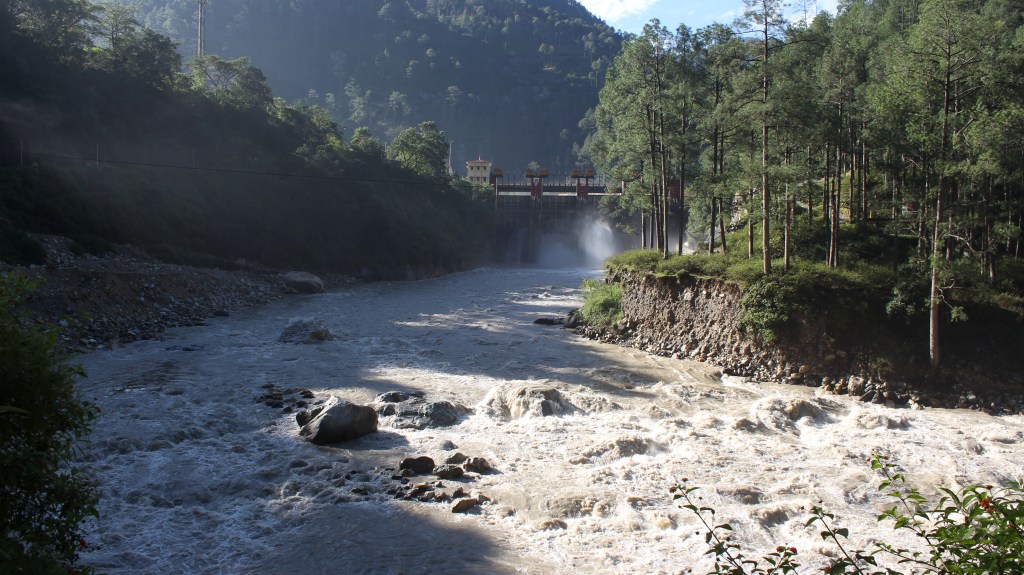
On August 5, at around 1:30 pm, Kheer Gaad, a stream in the Uttarakhand region, erupted in a massive surge behind Dharali village. The first tsunami-like wave rushed down the gentle left bank slope of the perennial Bhagirathi River. It submerged everything – commercial lodgings, resorts, restaurants, apple orchards, homes, and a vital road to the Sino-Indian border. Only a tiny fraction of the bustling marketplace along the river survived the flood’s fury.
In the main hamlet of Dharali, perched on a slight elevation, men, women, and children had just finished worshipping the village deity and dispersed for lunch. Hardood, a monsoon carnival, was about to begin, and people were in a festive mood. It was fortunate that the festivities had not yet begun, else the casualties could have been far more.
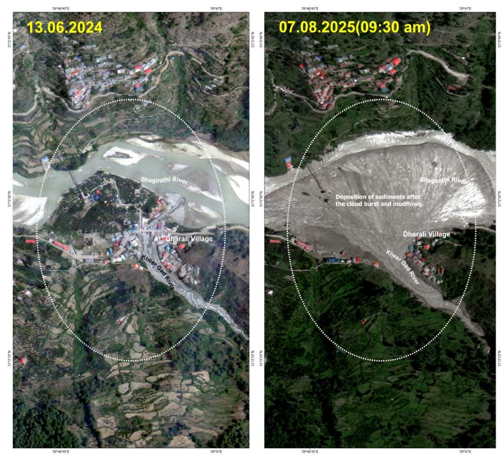
Below the battered village, nature reclaimed its alluvial slope, spreading ash-colored debris like a gargantuan hand fan. Later waves brought another 40-50 feet of fresh sludge and gravel, burying not only dozens of lives but also the Kalp Kedar temple complex—an early medieval shrine dedicated to Shiva. The subsequent waves deposited mounds of debris, which still have not been removed. The “destination tourism” business collapsed like a house of cards on the fan-shaped, wide alluvial plain, formed over time by the accumulation of sediments carried by the river. The map of Dharali was changed.
Dharali is not just a local tragedy. It shows how extreme weather — intensified by climate change and compounded by construction in fragile mountain terrain — is turning once-quiet valleys into disaster zones with increasing frequency. It has revealed the raw fury of nature against a relentless, expansionist political economy.
“Everything is finished,” a disheveled Narayan Panwar said, repeating the phrase in despair. “The Shiva temple is gone… No faith is left anymore.” His voice choked. Panwar’s homestay in Dharali, built with income from an orchard of 150-200 apple trees, the family’s sole livelihood, and his ancestral home were all lost. “There’s no land left even to pitch the tent the government gave me. And yes, they also gave a bank cheque of Rs 500,000; my son has gone to the city to deposit it,” he said, dismissing the ex gratia relief. Most painfully, he said, he lost his nephew, Akash, who had helped him run his business.
While outside investors and wealthy locals lost lucrative business opportunities, for many like Panwar, the modest homestays allowed many in the village to stay back, while the overwhelming majority migrated out of the state looking for menial jobs. Even after 25 years of statehood—following more than five decades under Uttar Pradesh—Uttarakhand has seen little agrarian reform to make traditional livelihoods economically viable. Instead, fertile valleys have slipped into neglect, and uneven national growth has forced its people into precarious labour in other states.
“It came without any sound,” narrates Santoshi, the eldest among a group of women who spoke to this reporter near the destroyed village. Vinita and Sandehi, both young homemakers and cultivators, said they rushed up the steep mountain slope as houses crashed around them. “Some of us trekked up to Kopang, others took shelter at Gangotri shrine, and returned here three days later,” Sandehi added. Kopang village, located at a higher altitude closer to the border with China, was abandoned following the 1962 Sino-Indian war. Dharali is now India’s first village downstream from both the border and the Gangotri glacier, the source of the Ganges River, also known as the Bhagirathi.
Pitched tents crowded the yard of a large, traditional house, which is the only housing structure still intact and habitable above the buried hamlet of Dharali. Tents were also pitched in the house’s yard; 15-20 displaced families had lived in this temporary commune ever since the relief operations started after the flood. Relief meals were cooked in the premises of the village deity’s temple, located right below the tent area, with ration supplies provided by the state government. As winter has begun, those with relatives or their own second home in lower areas have now left Dharali.
Of nearly 200 households that originally resided in Dharali, most had already relocated to a safer new hamlet called New Dharali, as the population multiplied over recent decades. Even though New Dharali was not affected by the flash floods, the residents were dependent on the now-buried marketplace; they lost their properties and livelihoods.
Over the past two and a half decades, Dharali, the wider Uttarakhand state, and indeed the Himalayan expanse itself, have endured repeated flash floods, destructive landslides and mudslides, intensified mostly by heavy rainfall but also by a few glacial lake outbursts. These have further turned into devastating disasters due to risky, ill-planned development in the fragile ecology. Each disaster not only swept away homes and infrastructure but also left lasting trauma and forced cycles of displacement and rebuilding.
Despite repeated disappointment with rehabilitation promises over the past 25 years, since the Uttarakhand state was formed, displaced Dharali residents still held onto hope. As one woman said after the August flood, “Many have come to ask about us, including the chief minister, the legislator, and officials. Our village chief has demanded resettlement for us.”
On March 6, the Uttarakhand government hosted Prime Minister Narendra Modi at Mukhba village, just across Dharali, where he promoted the state’s plan to widen roads for “all-weather” access, supporting year-round “destination tourism” in the pristine upper Ganges valley. The state’s push for shrine tourism for Hindus fueled investor interest in the hospitality sector. Yet, within six months of Modi’s outspoken support for the corporatization of travel and tourism, the Kheer Gaad alluvial slope’s investment appeal stood shattered. The idea proved ill-conceived. Accountability for the tragedy has remained strikingly muted, with state efforts at every turn to portray the disaster as a mere “natural calamity” rather than a systemically enabled ecological collapse.

Dispute over the Dead and the Missing
Officially, among 44 Indian nationals dead or missing, only one, 26-year-old Aakash Singh, the nephew of Narayan Panwar, was confirmed dead. His body was found on the riverbank by the state relief forces. The rest—43 Indians, plus roughly half as many Nepalese migrants— remain listed as “missing” as of mid-October.
Dharali residents initially estimated the casualties as exceeding 80, with eight young Dharali natives among them. The others were tourists and migrant workers. Seven villagers, including a family of three, remain buried at least 40 feet deep. The authorities would not, however, bring the dead home. Whether they would not, or could not, their failure echoed in the families’ silence. Worse still, a recent survey at New Dharali, an extended expanse of the original hamlet, by a retired army colonel, with experience of post-disaster reconstruction at Kedarnath, has doubled the estimate of the dead or missing to around 150.
Many people remain missing as piles of debris have not been cleared away in the last four months. The death toll is under dispute. The government maintained a confirmed death toll of only four for months. In December, retired Colonel and dissident BJP leader Ajay Kothiyal claimed that 147 people remain buried under debris—an assertion that sharply contradicts the Uttarakhand government’s official figure. The government then issued a clarification, revising the figure of deaths to 16. The timing of Kothiyal’s claim has intensified scrutiny, as it comes long after rescue operations were formally wound down. The administration maintains that only 52 were missing, citing later verifications, duplicate names, and migrant workers traced to Nepal.
In August itself, the reluctance to record deaths smacked of official distrust deeply ingrained in a bureaucracy alienated from the citizenry. A nodal officer in Uttarkashi cynically remarked, “They may feign death… so that someone could lay claim to the compensation money.” Unwittingly, he also revealed that it was only a lone survivor who was relied upon to get the names of the missing Nepalese individuals.
The locals, on the other hand, were sure that most of the victims were Nepalese and Bihari migrant workers resting in rented rooms at lunch time. “The Nepalese worked in our apple orchards for decades, sometimes with their families,” said village chief Ajay Negi. “Biharis mostly did masonry.” This understanding of the locals who lived in a symbiotic relation with the migrants did not reflect in the official list. Two months after the incident, the nodal officer I spoke to remained unaware of the migrants’ origins. Home addresses, even names, of Muslims and possibly other marginalized groups were absent from the final list.
A Symptom of a Systemic Crisis
Dharali was not the only disaster in that valley this monsoon. Multiple flash floods tore through Uttarakhand’s upper Bhagirathi valley on August 5. They were not acts of nature alone. It was an outcome of years of state-induced ecological destabilization driven by deforestation, road construction, the political promotion of Himalayan “development,” and, most recently, a concerted push for all-weather, high-altitude shrine tourism. What unfolded that monsoon day reflected a pattern playing out unfettered across the Western Himalayas, where state-sanctioned projects have stripped mountain slopes of their natural resilience, transforming rain-fed valleys into zones of recurring disasters. The rest of the Himalayan range is being drawn into the same calamitous vortex, with regional variations.
The chain of flash floods came through five adjoining streams, including Kheer Gad, which joins the main Ganges River at various places. In a matter of hours, waves of rocks, mud, and debris choked the riverbanks, overwhelming the landscape. Only one of these five streams, across a 20 km stretch of the national highway between the ecologically sensitive Jhala and Jangla area, escaped destruction. According to geologists, its course cut through a dense forest of Deodar trees whose roots held the fragile slopes together.
“The Deodar roots prevented the soil from collapsing,” explained geologist Navin Juyal. “That was why no disaster occurred there.” He pointed to a clear link between deforestation and destruction. However, the government and its agency, the Border and Road Organisation, intend to widen this highway across Jhala and Jangla, with 6,000 trees on slopes marked for felling.
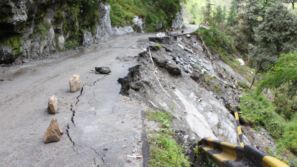
Each of the other four streams unleashed successive waves of devastation. Just downstream of Dharali, the Tel Gad stream swept into an Indian Army camp at Harsil, damming the Bhagirathi and creating a temporary lake. The national highway to Gangotri and the Chinese border, with an Army helipad alongside, lay submerged for weeks. Nine soldiers were killed, most buried under the debris. Twenty-three others barely survived the rockfall. Twenty-five kilometers farther down, another torrent from Son Gad washed away an entire stretch of the same highway, as the Bhagirathi’s force was redirected toward the opposite bank. Further downstream, a 40-metre surge along Limcha Gad swept away a key iron bridge. By nightfall, the vital highway lay critically severed at multiple places; both military access to one of India’s sensitive border posts and year-round, destination-centric shrine tourism were decimated by the flash floods.
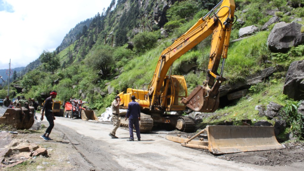
“The Border Roads Organisation took a full week just to rebuild the iron bridge,” recalled police officer Nitin Chauhan, who oversaw rescue and relief in Harsil village. “Only then could road restoration begin elsewhere,” he added. Partial connectivity to Harsil was restored more than two weeks later, even as the threat of fresh landslides persisted for months, with several stretches continuing to give way. Pilgrim routes to Gangotri remained blocked; troop movement slowed to a crawl. Even as workers raced to reopen the highway, torrential rains and unstable slopes repeatedly set them back.
The disaster exposed the dangerous contradiction at the heart of India’s Himalayan policy: state-promoted development that corrodes the ecological foundations of the mountains themselves. Despite well-documented geological fragility, the Supreme Court’s 2021 ruling permitted widening the Gangotri Highway from 5–7 feet to 10–12 feet, despite controversy over tree-felling and consequent landslide risks. The high-traffic highway connects five top spots visited by Hindu pilgrims and other tourists, and four of these are part of the Char Dham pilgrimage circuit. The highways hold a key logistical utility for military movements to India’s border with China within Uttarakhand. Prime Minister Modi’s March 6 speech near Dharali echoed the vision of road expansion and tourism as engines of prosperity. And then came the heavy monsoons accompanied by the flash floods, revealing what this approach to ‘development’ has done. With forests cleared, slopes destabilized, and riverbeds choked by construction debris, the valley’s natural defenses had veritably collapsed long before the rains arrived.
Neither Dharali nor the Bhagirathi valley was an isolated scene of crisis this year. From July to September, similar floods and landslides struck Uttarkashi, Rudraprayag, Chamoli, Pauri Garhwal, and Dehradun districts in the hill state of Uttarakhand. Right across the Western Himalayas, mountain torrents washed away roads, bridges, and entire settlements from the lower to the middle and higher reaches of the Himalayan ranges. Districts and states across the Indo-Pak border were unsparingly ravaged by extreme weather events during this period.
The 2025 monsoon in the Indian subcontinent has marked one of the most widespread ecological breakdowns in recent memory. At its root lie not only intensifying climate patterns, but the relentless state vision of “connectivity”—a model of development that fetishizes the prosperity of a few on the ruins of a crumbling ecology.
Tracing the Triggers of the Dharali Disaster
Initial reports from Uttarakhand government sources and media quickly pointed to a cloudburst as the cause of the Dharali disaster on August 5. The cloudburst claim resurfaced time and again in neighboring Himachal Pradesh and Jammu and Kashmir, where flash floods and landslides had been on the rampage for over ten weeks from July to September.
Characterized by hefty rains of over 100 millimeters per hour, accompanied by thunder, cloudbursts are often regarded as natural phenomena beyond human control, making them convenient explanations for heart-wrenching disasters. However, official data tells a different story for this region. While rainfall was indeed heavy, data on August 5 shows a dip, not a spike, making a classic cloudburst unlikely in this event. On-field instrumentation for monitoring actual rainfall is severely lacking across the Himalayan states; this makes post-disaster analysis, as a means to determine the precise extreme weather event, quite difficult.
Shivraj Panwar, a mountaineering instructor and resident of Dharali, joined an official expedition to investigate the glacial origins of the Kheer Gad stream two days after the disaster. The team ascended to 4,800 meters, right beneath the Srikant glacier, one that has shrunk drastically over the years, losing its internal permafrost and frozen stability, largely due to global warming. Unlike healthier glaciers nearby, the Srikant glacier is surrounded by loose, unconsolidated moraine—mud, gravel, and rocks that are vulnerable to sliding when saturated with rain.
Panwar’s team found no evidence of a glacial lake outburst flood (GLOF) or sudden glacier rupture, which was presented as a possible cause by several media outlets. Instead, there was a 100-meter scree fall—an initial, relatively minor, landslide—that marked the beginning of a cascading debris flow. The paraglacial landslide darkened the flow and charged the Kheer Gad stream, which grew increasingly turbulent as it sped downstream. Shepherds camped near the scree described how they felt the earth tremble before the water turned turbid, a vivid sign of the sliding morainic mass.
Geologist Navin Juyal described the para-glacial moraine zone as “an army waiting for marching orders,” where extreme weather or minor triggers cascade into devastating debris flows. Blockages caused temporary lakes at the necks of narrow gorges, which eventually burst forth, further accelerating the flood downstream with destructive force.
Days later, a local media channel, Baramasa, released a simulation recreating the cascading disaster to confirm heavy precipitation and destabilized moraine as its core drivers. Yet, despite scientific clarity, political and economic interests fueled continuing blame-shifting. Authorities pointed fingers at residents for building in hazard zones, while business interests remained critical of the “environmentalist lobby,” mirthlessly advocating road widening and infrastructure expansion.
Near Dharali’s market area—now buried under debris—construction of houses, lodges, shops, and hotels had accelerated over the past two decades. This was propelled by growing tourism pushed by the state and pilgrim traffic to the Gangotri shrine, around 20 kilometres away.
The Dharali disaster echoes earlier calamities, such as the 2013 Kedarnath tragedy, revealing a systemic failure to heed ecological warnings. Even after the immense loss and destruction, administrators reinforced the unsafe construction with concrete walls that were not equipped to withstand the enormous impact of high-altitude flash floods. Meanwhile, political endorsements, including the Prime Minister’s call for development, overrode environmental restrictions, locking the region into an incessant cycle of repeated disaster.
The case illustrates how Himalayan mega-disasters emerge not solely from sudden weather extremes but from interactions with degraded and fragile landscapes, intensified by systemic interference. It demands a reevaluation of disaster narratives that simplify such catastrophes as ‘natural,’ and calls for urgent transformative action to usher in mountain environment governance.
Disasters waiting to happen
“Traditionally, glaciers extended down to approximately 3,800-4,000 meters above mean sea level, but many have now receded to as high an elevation as 8,000 to 10,000 meters,” DP Dobhal, a pioneering glaciologist with extensive experience across the Hindu Kush Himalayas, explains the recent weather events in light of observed climatic changes in the high Himalayas.
“The para-glacial moraine, often containing permafrost at its base, has been loosening up in recent years, due to warmer temperatures, rising faster at these altitudes than the global average.” The higher rate of warming in the snowbound parts of the mountains, as compared to the plains below, has been squarely attributed to what is known as the “albedo effect.”
In a recent critique of ongoing development projects–the road widening, shrine tourism, and hydropower dams—in the context of the Dharali disaster, geologists Juyal and his Uttarkashi-based colleague Hemant Dhyan suggest measures for disaster prevention in BESZ–the Bhagirathi valley Eco-Sensitive Zone. According to them, increasing commercial activities, with their incumbent vehicular traffic and airborne transport (helicopter sorties), have multiplied the black carbon content of atmospheric aerosols in the snowbound tracts of glacial regions. The dark color of the impurities has led to more absorption and less reflection of radiation, essentially the sun’s energy, which, along with the shrinkage of forest cover, generates a relatively higher rate of warming in the higher altitudes.
“Compared to fluffy snow, as rains replaced snowfalls with the warming at higher reaches during the monsoon, raindrops have grown larger and heavier, causing erosion at their impact sites,” Dobhal said, elucidating the mechanics of hazards turning into disasters. “The eroded moraine flows with rainwater down the slopes. Such unabated erosion, along with saturation of the moraine, caused by rain, tends to loosen the earth materials, which then cascade down, contributing to the turbidity of glacial rivulets. Obstructions on their way in the form of narrow gorges, and commercial constructions, further downstream, turn the otherwise benign rivulets into monstrous floods and landslides, birthing catastrophes.”
That was how excessive rain in the climatically susceptible higher altitudes led to the upending of lives and livelihoods all over the Western Himalayas this year. It kicked off as early as mid-April from Ramban in Jammu division, where a crucial road link to the Kashmir valley was severed by flash floods and landslides, with the Chenab flowing in spate. It was the first of a series of extreme weather events triggered by heavy rains this summer. The rains resulted from the first of a series of untimely Western Disturbances that hit the Himalayas right until mid-September. As monsoon winds hit the hills in the second fortnight of June, their interactions with multiple disturbances emerging, one after another, from the Mediterranean and Caspian seas, brought torrential downpours that took hundreds of lives and hit livelihoods like never before.
An alleged cloudburst struck a thickly populated pilgrim camp at Chashoti in Kishtwar district of Jammu division, on August 14, days after the Dharali catastrophe. Later that month, the pilgrimage route to Vaishno Devi, one of the most-flocked shrines of north India, was hit by another suspected cloudburst. Heavy rain in its train caused shock floods in the Tawi and Sutlej rivers. As the rivers rose to never-imagined levels, floods spread terror in the midst of a recently constructed pair of riverfronts on both banks in Jammu city. The rapidly flowing waters heaped misery upon the vast countryside, on both sides of the line of control, over multiple districts of West Punjab (Pakistan) and its eastern flank (Indian Punjab).
Himachal Pradesh, meanwhile, bore the maximum brunt, with Mandi, Kullu, and Shimla districts in the Middle Himalayas being witness to the sheer rage of mountain rivers that mercilessly reduced the state’s much-epitomized “developed network” of four-lane highways and hydropower dams to shambles within weeks. The infrastructural damages and losses were markedly concentrated near sites of the still ongoing road widening and muck dumping, and hydropower dam projects.
Roads, bridges, and entire settlements were washed away from the lower to the middle and higher reaches of the Western Himalayas. With short intervals in between, the spate of disasters lasted until September, when they finally struck the seismically sensitive boundary between the Himalayas and the Shivaliks, in Dehradun, at the foothills of Mussoorie. This sent alarm bells ringing far and wide. The cold deserts of Lahaul and Spiti, and Leh, Ladakh, which fall in the Himalayan rain shadow region that extends up to Tibet, had a close shave, with no serious damage reported as yet, but unprecedented showers in this extremely fragile zone portended a major climate threat, stirring the national environmental conscience over the critical crossroads at which the Himalayan region stands.
The Himalayan frontier is known to have endowed the Indian subcontinent with a climatically congenial ecology that has fostered, over tens of millennia, a unique genetic diversity of the human race amidst the odds of natural hazards. But this region now appears to stand at a critical crossroad. The spate of disasters from Dharali to Dehradun, and across national borders, exposes how, in the absence of a transformative paradigm of resilient growth that could mitigate the climatic challenges of glacial retreat and monsoon variability, the state-stimulated fetish of furthering untrammeled development, and a court-minted template of shrine tourism, end up eroding the fragile mountain ecosystems.
Presuming the developmental scenario of 2025 not to be a tipping point for the Western Himalaya’s climate resilience, the story of the monsoon disasters could be a call to reckon with the catastrophic costs of ignoring nature’s limits in the pursuit of the extractive value of its endowments. As such disasters grow more frequent in the Himalayas, these emerge as part of the global environmental collapse — and the world cannot afford to look away.

Disaster as Policy: Dharali Flash Floods Reveal the Making of a Himalayan Catastrophe
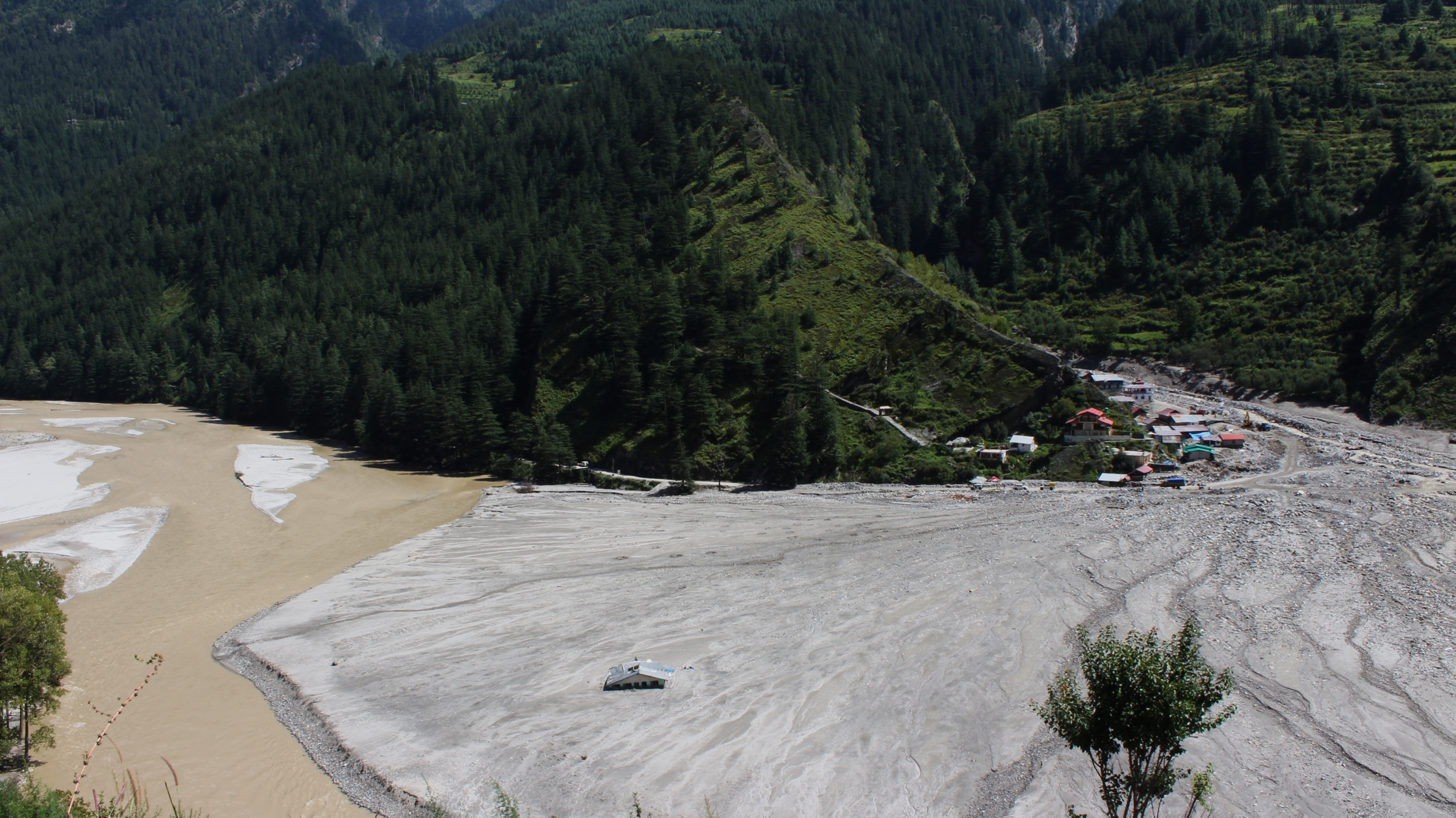
Several resorts, multi-storey hotels and homestays were destroyed in a single wave at Dharali village in Uttarakhand. Later waves deposited 40-50 feet of additional debris, spread in a fan-like shape. Photo by Shikha Rahi
The 2025 Dharali flash flood exposed how the expansion of tourism and infrastructure in the ecologically fragile Higher Himalayas, compounded by the effects of climate change in the paraglacial zone, culminated in a devastating disaster masquerading as a natural calamity.
High in northern India’s Himalayan state of Uttarakhand, flash floods and mudslides ripped through the village of Dharali, sweeping away everything in its way. On social media, videos of the floods flattening buildings on the riverbanks in seconds shocked people across the country. Although it was not the first flash flood at Dharali, current governance processes have converted this hazard into a tragic disaster.
On August 5, at around 1:30 pm, Kheer Gaad, a stream in the Uttarakhand region, erupted in a massive surge behind Dharali village. The first tsunami-like wave rushed down the gentle left bank slope of the perennial Bhagirathi River. It submerged everything – commercial lodgings, resorts, restaurants, apple orchards, homes, and a vital road to the Sino-Indian border. Only a tiny fraction of the bustling marketplace along the river survived the flood’s fury.
In the main hamlet of Dharali, perched on a slight elevation, men, women, and children had just finished worshipping the village deity and dispersed for lunch. Hardood, a monsoon carnival, was about to begin, and people were in a festive mood. It was fortunate that the festivities had not yet begun, else the casualties could have been far more.
Below the battered village, nature reclaimed its alluvial slope, spreading ash-colored debris like a gargantuan hand fan. Later waves brought another 40-50 feet of fresh sludge and gravel, burying not only dozens of lives but also the Kalp Kedar temple complex—an early medieval shrine dedicated to Shiva. The subsequent waves deposited mounds of debris, which still have not been removed. The “destination tourism” business collapsed like a house of cards on the fan-shaped, wide alluvial plain, formed over time by the accumulation of sediments carried by the river. The map of Dharali was changed.
Dharali is not just a local tragedy. It shows how extreme weather — intensified by climate change and compounded by construction in fragile mountain terrain — is turning once-quiet valleys into disaster zones with increasing frequency. It has revealed the raw fury of nature against a relentless, expansionist political economy.
“Everything is finished,” a disheveled Narayan Panwar said, repeating the phrase in despair. “The Shiva temple is gone… No faith is left anymore.” His voice choked. Panwar’s homestay in Dharali, built with income from an orchard of 150-200 apple trees, the family’s sole livelihood, and his ancestral home were all lost. “There’s no land left even to pitch the tent the government gave me. And yes, they also gave a bank cheque of Rs 500,000; my son has gone to the city to deposit it,” he said, dismissing the ex gratia relief. Most painfully, he said, he lost his nephew, Akash, who had helped him run his business.
While outside investors and wealthy locals lost lucrative business opportunities, for many like Panwar, the modest homestays allowed many in the village to stay back, while the overwhelming majority migrated out of the state looking for menial jobs. Even after 25 years of statehood—following more than five decades under Uttar Pradesh—Uttarakhand has seen little agrarian reform to make traditional livelihoods economically viable. Instead, fertile valleys have slipped into neglect, and uneven national growth has forced its people into precarious labour in other states.
“It came without any sound,” narrates Santoshi, the eldest among a group of women who spoke to this reporter near the destroyed village. Vinita and Sandehi, both young homemakers and cultivators, said they rushed up the steep mountain slope as houses crashed around them. “Some of us trekked up to Kopang, others took shelter at Gangotri shrine, and returned here three days later,” Sandehi added. Kopang village, located at a higher altitude closer to the border with China, was abandoned following the 1962 Sino-Indian war. Dharali is now India’s first village downstream from both the border and the Gangotri glacier, the source of the Ganges River, also known as the Bhagirathi.
Pitched tents crowded the yard of a large, traditional house, which is the only housing structure still intact and habitable above the buried hamlet of Dharali. Tents were also pitched in the house’s yard; 15-20 displaced families had lived in this temporary commune ever since the relief operations started after the flood. Relief meals were cooked in the premises of the village deity’s temple, located right below the tent area, with ration supplies provided by the state government. As winter has begun, those with relatives or their own second home in lower areas have now left Dharali.
Of nearly 200 households that originally resided in Dharali, most had already relocated to a safer new hamlet called New Dharali, as the population multiplied over recent decades. Even though New Dharali was not affected by the flash floods, the residents were dependent on the now-buried marketplace; they lost their properties and livelihoods.
Over the past two and a half decades, Dharali, the wider Uttarakhand state, and indeed the Himalayan expanse itself, have endured repeated flash floods, destructive landslides and mudslides, intensified mostly by heavy rainfall but also by a few glacial lake outbursts. These have further turned into devastating disasters due to risky, ill-planned development in the fragile ecology. Each disaster not only swept away homes and infrastructure but also left lasting trauma and forced cycles of displacement and rebuilding.
Despite repeated disappointment with rehabilitation promises over the past 25 years, since the Uttarakhand state was formed, displaced Dharali residents still held onto hope. As one woman said after the August flood, “Many have come to ask about us, including the chief minister, the legislator, and officials. Our village chief has demanded resettlement for us.”
On March 6, the Uttarakhand government hosted Prime Minister Narendra Modi at Mukhba village, just across Dharali, where he promoted the state’s plan to widen roads for “all-weather” access, supporting year-round “destination tourism” in the pristine upper Ganges valley. The state’s push for shrine tourism for Hindus fueled investor interest in the hospitality sector. Yet, within six months of Modi’s outspoken support for the corporatization of travel and tourism, the Kheer Gaad alluvial slope’s investment appeal stood shattered. The idea proved ill-conceived. Accountability for the tragedy has remained strikingly muted, with state efforts at every turn to portray the disaster as a mere “natural calamity” rather than a systemically enabled ecological collapse.
Dispute over the Dead and the Missing
Officially, among 44 Indian nationals dead or missing, only one, 26-year-old Aakash Singh, the nephew of Narayan Panwar, was confirmed dead. His body was found on the riverbank by the state relief forces. The rest—43 Indians, plus roughly half as many Nepalese migrants— remain listed as “missing” as of mid-October.
Dharali residents initially estimated the casualties as exceeding 80, with eight young Dharali natives among them. The others were tourists and migrant workers. Seven villagers, including a family of three, remain buried at least 40 feet deep. The authorities would not, however, bring the dead home. Whether they would not, or could not, their failure echoed in the families’ silence. Worse still, a recent survey at New Dharali, an extended expanse of the original hamlet, by a retired army colonel, with experience of post-disaster reconstruction at Kedarnath, has doubled the estimate of the dead or missing to around 150.
Many people remain missing as piles of debris have not been cleared away in the last four months. The death toll is under dispute. The government maintained a confirmed death toll of only four for months. In December, retired Colonel and dissident BJP leader Ajay Kothiyal claimed that 147 people remain buried under debris—an assertion that sharply contradicts the Uttarakhand government’s official figure. The government then issued a clarification, revising the figure of deaths to 16. The timing of Kothiyal’s claim has intensified scrutiny, as it comes long after rescue operations were formally wound down. The administration maintains that only 52 were missing, citing later verifications, duplicate names, and migrant workers traced to Nepal.
In August itself, the reluctance to record deaths smacked of official distrust deeply ingrained in a bureaucracy alienated from the citizenry. A nodal officer in Uttarkashi cynically remarked, “They may feign death… so that someone could lay claim to the compensation money.” Unwittingly, he also revealed that it was only a lone survivor who was relied upon to get the names of the missing Nepalese individuals.
The locals, on the other hand, were sure that most of the victims were Nepalese and Bihari migrant workers resting in rented rooms at lunch time. “The Nepalese worked in our apple orchards for decades, sometimes with their families,” said village chief Ajay Negi. “Biharis mostly did masonry.” This understanding of the locals who lived in a symbiotic relation with the migrants did not reflect in the official list. Two months after the incident, the nodal officer I spoke to remained unaware of the migrants’ origins. Home addresses, even names, of Muslims and possibly other marginalized groups were absent from the final list.
A Symptom of a Systemic Crisis
Dharali was not the only disaster in that valley this monsoon. Multiple flash floods tore through Uttarakhand’s upper Bhagirathi valley on August 5. They were not acts of nature alone. It was an outcome of years of state-induced ecological destabilization driven by deforestation, road construction, the political promotion of Himalayan “development,” and, most recently, a concerted push for all-weather, high-altitude shrine tourism. What unfolded that monsoon day reflected a pattern playing out unfettered across the Western Himalayas, where state-sanctioned projects have stripped mountain slopes of their natural resilience, transforming rain-fed valleys into zones of recurring disasters. The rest of the Himalayan range is being drawn into the same calamitous vortex, with regional variations.
The chain of flash floods came through five adjoining streams, including Kheer Gad, which joins the main Ganges River at various places. In a matter of hours, waves of rocks, mud, and debris choked the riverbanks, overwhelming the landscape. Only one of these five streams, across a 20 km stretch of the national highway between the ecologically sensitive Jhala and Jangla area, escaped destruction. According to geologists, its course cut through a dense forest of Deodar trees whose roots held the fragile slopes together.
“The Deodar roots prevented the soil from collapsing,” explained geologist Navin Juyal. “That was why no disaster occurred there.” He pointed to a clear link between deforestation and destruction. However, the government and its agency, the Border and Road Organisation, intend to widen this highway across Jhala and Jangla, with 6,000 trees on slopes marked for felling.
Each of the other four streams unleashed successive waves of devastation. Just downstream of Dharali, the Tel Gad stream swept into an Indian Army camp at Harsil, damming the Bhagirathi and creating a temporary lake. The national highway to Gangotri and the Chinese border, with an Army helipad alongside, lay submerged for weeks. Nine soldiers were killed, most buried under the debris. Twenty-three others barely survived the rockfall. Twenty-five kilometers farther down, another torrent from Son Gad washed away an entire stretch of the same highway, as the Bhagirathi’s force was redirected toward the opposite bank. Further downstream, a 40-metre surge along Limcha Gad swept away a key iron bridge. By nightfall, the vital highway lay critically severed at multiple places; both military access to one of India’s sensitive border posts and year-round, destination-centric shrine tourism were decimated by the flash floods.
“The Border Roads Organisation took a full week just to rebuild the iron bridge,” recalled police officer Nitin Chauhan, who oversaw rescue and relief in Harsil village. “Only then could road restoration begin elsewhere,” he added. Partial connectivity to Harsil was restored more than two weeks later, even as the threat of fresh landslides persisted for months, with several stretches continuing to give way. Pilgrim routes to Gangotri remained blocked; troop movement slowed to a crawl. Even as workers raced to reopen the highway, torrential rains and unstable slopes repeatedly set them back.
The disaster exposed the dangerous contradiction at the heart of India’s Himalayan policy: state-promoted development that corrodes the ecological foundations of the mountains themselves. Despite well-documented geological fragility, the Supreme Court’s 2021 ruling permitted widening the Gangotri Highway from 5–7 feet to 10–12 feet, despite controversy over tree-felling and consequent landslide risks. The high-traffic highway connects five top spots visited by Hindu pilgrims and other tourists, and four of these are part of the Char Dham pilgrimage circuit. The highways hold a key logistical utility for military movements to India’s border with China within Uttarakhand. Prime Minister Modi’s March 6 speech near Dharali echoed the vision of road expansion and tourism as engines of prosperity. And then came the heavy monsoons accompanied by the flash floods, revealing what this approach to ‘development’ has done. With forests cleared, slopes destabilized, and riverbeds choked by construction debris, the valley’s natural defenses had veritably collapsed long before the rains arrived.
Neither Dharali nor the Bhagirathi valley was an isolated scene of crisis this year. From July to September, similar floods and landslides struck Uttarkashi, Rudraprayag, Chamoli, Pauri Garhwal, and Dehradun districts in the hill state of Uttarakhand. Right across the Western Himalayas, mountain torrents washed away roads, bridges, and entire settlements from the lower to the middle and higher reaches of the Himalayan ranges. Districts and states across the Indo-Pak border were unsparingly ravaged by extreme weather events during this period.
The 2025 monsoon in the Indian subcontinent has marked one of the most widespread ecological breakdowns in recent memory. At its root lie not only intensifying climate patterns, but the relentless state vision of “connectivity”—a model of development that fetishizes the prosperity of a few on the ruins of a crumbling ecology.
Tracing the Triggers of the Dharali Disaster
Initial reports from Uttarakhand government sources and media quickly pointed to a cloudburst as the cause of the Dharali disaster on August 5. The cloudburst claim resurfaced time and again in neighboring Himachal Pradesh and Jammu and Kashmir, where flash floods and landslides had been on the rampage for over ten weeks from July to September.
Characterized by hefty rains of over 100 millimeters per hour, accompanied by thunder, cloudbursts are often regarded as natural phenomena beyond human control, making them convenient explanations for heart-wrenching disasters. However, official data tells a different story for this region. While rainfall was indeed heavy, data on August 5 shows a dip, not a spike, making a classic cloudburst unlikely in this event. On-field instrumentation for monitoring actual rainfall is severely lacking across the Himalayan states; this makes post-disaster analysis, as a means to determine the precise extreme weather event, quite difficult.
Shivraj Panwar, a mountaineering instructor and resident of Dharali, joined an official expedition to investigate the glacial origins of the Kheer Gad stream two days after the disaster. The team ascended to 4,800 meters, right beneath the Srikant glacier, one that has shrunk drastically over the years, losing its internal permafrost and frozen stability, largely due to global warming. Unlike healthier glaciers nearby, the Srikant glacier is surrounded by loose, unconsolidated moraine—mud, gravel, and rocks that are vulnerable to sliding when saturated with rain.
Panwar’s team found no evidence of a glacial lake outburst flood (GLOF) or sudden glacier rupture, which was presented as a possible cause by several media outlets. Instead, there was a 100-meter scree fall—an initial, relatively minor, landslide—that marked the beginning of a cascading debris flow. The paraglacial landslide darkened the flow and charged the Kheer Gad stream, which grew increasingly turbulent as it sped downstream. Shepherds camped near the scree described how they felt the earth tremble before the water turned turbid, a vivid sign of the sliding morainic mass.
Geologist Navin Juyal described the para-glacial moraine zone as “an army waiting for marching orders,” where extreme weather or minor triggers cascade into devastating debris flows. Blockages caused temporary lakes at the necks of narrow gorges, which eventually burst forth, further accelerating the flood downstream with destructive force.
Days later, a local media channel, Baramasa, released a simulation recreating the cascading disaster to confirm heavy precipitation and destabilized moraine as its core drivers. Yet, despite scientific clarity, political and economic interests fueled continuing blame-shifting. Authorities pointed fingers at residents for building in hazard zones, while business interests remained critical of the “environmentalist lobby,” mirthlessly advocating road widening and infrastructure expansion.
Near Dharali’s market area—now buried under debris—construction of houses, lodges, shops, and hotels had accelerated over the past two decades. This was propelled by growing tourism pushed by the state and pilgrim traffic to the Gangotri shrine, around 20 kilometres away.
The Dharali disaster echoes earlier calamities, such as the 2013 Kedarnath tragedy, revealing a systemic failure to heed ecological warnings. Even after the immense loss and destruction, administrators reinforced the unsafe construction with concrete walls that were not equipped to withstand the enormous impact of high-altitude flash floods. Meanwhile, political endorsements, including the Prime Minister’s call for development, overrode environmental restrictions, locking the region into an incessant cycle of repeated disaster.
The case illustrates how Himalayan mega-disasters emerge not solely from sudden weather extremes but from interactions with degraded and fragile landscapes, intensified by systemic interference. It demands a reevaluation of disaster narratives that simplify such catastrophes as ‘natural,’ and calls for urgent transformative action to usher in mountain environment governance.
Disasters waiting to happen
“Traditionally, glaciers extended down to approximately 3,800-4,000 meters above mean sea level, but many have now receded to as high an elevation as 8,000 to 10,000 meters,” DP Dobhal, a pioneering glaciologist with extensive experience across the Hindu Kush Himalayas, explains the recent weather events in light of observed climatic changes in the high Himalayas.
“The para-glacial moraine, often containing permafrost at its base, has been loosening up in recent years, due to warmer temperatures, rising faster at these altitudes than the global average.” The higher rate of warming in the snowbound parts of the mountains, as compared to the plains below, has been squarely attributed to what is known as the “albedo effect.”
In a recent critique of ongoing development projects–the road widening, shrine tourism, and hydropower dams—in the context of the Dharali disaster, geologists Juyal and his Uttarkashi-based colleague Hemant Dhyan suggest measures for disaster prevention in BESZ–the Bhagirathi valley Eco-Sensitive Zone. According to them, increasing commercial activities, with their incumbent vehicular traffic and airborne transport (helicopter sorties), have multiplied the black carbon content of atmospheric aerosols in the snowbound tracts of glacial regions. The dark color of the impurities has led to more absorption and less reflection of radiation, essentially the sun’s energy, which, along with the shrinkage of forest cover, generates a relatively higher rate of warming in the higher altitudes.
“Compared to fluffy snow, as rains replaced snowfalls with the warming at higher reaches during the monsoon, raindrops have grown larger and heavier, causing erosion at their impact sites,” Dobhal said, elucidating the mechanics of hazards turning into disasters. “The eroded moraine flows with rainwater down the slopes. Such unabated erosion, along with saturation of the moraine, caused by rain, tends to loosen the earth materials, which then cascade down, contributing to the turbidity of glacial rivulets. Obstructions on their way in the form of narrow gorges, and commercial constructions, further downstream, turn the otherwise benign rivulets into monstrous floods and landslides, birthing catastrophes.”
That was how excessive rain in the climatically susceptible higher altitudes led to the upending of lives and livelihoods all over the Western Himalayas this year. It kicked off as early as mid-April from Ramban in Jammu division, where a crucial road link to the Kashmir valley was severed by flash floods and landslides, with the Chenab flowing in spate. It was the first of a series of extreme weather events triggered by heavy rains this summer. The rains resulted from the first of a series of untimely Western Disturbances that hit the Himalayas right until mid-September. As monsoon winds hit the hills in the second fortnight of June, their interactions with multiple disturbances emerging, one after another, from the Mediterranean and Caspian seas, brought torrential downpours that took hundreds of lives and hit livelihoods like never before.
An alleged cloudburst struck a thickly populated pilgrim camp at Chashoti in Kishtwar district of Jammu division, on August 14, days after the Dharali catastrophe. Later that month, the pilgrimage route to Vaishno Devi, one of the most-flocked shrines of north India, was hit by another suspected cloudburst. Heavy rain in its train caused shock floods in the Tawi and Sutlej rivers. As the rivers rose to never-imagined levels, floods spread terror in the midst of a recently constructed pair of riverfronts on both banks in Jammu city. The rapidly flowing waters heaped misery upon the vast countryside, on both sides of the line of control, over multiple districts of West Punjab (Pakistan) and its eastern flank (Indian Punjab).
Himachal Pradesh, meanwhile, bore the maximum brunt, with Mandi, Kullu, and Shimla districts in the Middle Himalayas being witness to the sheer rage of mountain rivers that mercilessly reduced the state’s much-epitomized “developed network” of four-lane highways and hydropower dams to shambles within weeks. The infrastructural damages and losses were markedly concentrated near sites of the still ongoing road widening and muck dumping, and hydropower dam projects.
Roads, bridges, and entire settlements were washed away from the lower to the middle and higher reaches of the Western Himalayas. With short intervals in between, the spate of disasters lasted until September, when they finally struck the seismically sensitive boundary between the Himalayas and the Shivaliks, in Dehradun, at the foothills of Mussoorie. This sent alarm bells ringing far and wide. The cold deserts of Lahaul and Spiti, and Leh, Ladakh, which fall in the Himalayan rain shadow region that extends up to Tibet, had a close shave, with no serious damage reported as yet, but unprecedented showers in this extremely fragile zone portended a major climate threat, stirring the national environmental conscience over the critical crossroads at which the Himalayan region stands.
The Himalayan frontier is known to have endowed the Indian subcontinent with a climatically congenial ecology that has fostered, over tens of millennia, a unique genetic diversity of the human race amidst the odds of natural hazards. But this region now appears to stand at a critical crossroad. The spate of disasters from Dharali to Dehradun, and across national borders, exposes how, in the absence of a transformative paradigm of resilient growth that could mitigate the climatic challenges of glacial retreat and monsoon variability, the state-stimulated fetish of furthering untrammeled development, and a court-minted template of shrine tourism, end up eroding the fragile mountain ecosystems.
Presuming the developmental scenario of 2025 not to be a tipping point for the Western Himalaya’s climate resilience, the story of the monsoon disasters could be a call to reckon with the catastrophic costs of ignoring nature’s limits in the pursuit of the extractive value of its endowments. As such disasters grow more frequent in the Himalayas, these emerge as part of the global environmental collapse — and the world cannot afford to look away.